
Drone Services Minnesota
Same-Day Results
What drone services deliver the fastest, most reliable results in Minnesota?
From emergency lost pet searches to thermal inspections, every service is built to solve urgent problems fast.
SAME-DAY
SERVICE
LICENSED &
INSURED
HIGH-PRECISION
RESULTS
FAST
RESPONSE
5-Star Rated
Drone Services Minnesota
Trusted Across Owatonna MN, Rochester MN, Minneapolis MN
SERVICES WE PROVIDE ACROSS MINNESOTA


Why choose SkyView Drone Services MN?
FAA Part 107 Certified Drone Pilots
Fully Insured Commercial Operations
Same-Day Service Available Across Minnesota
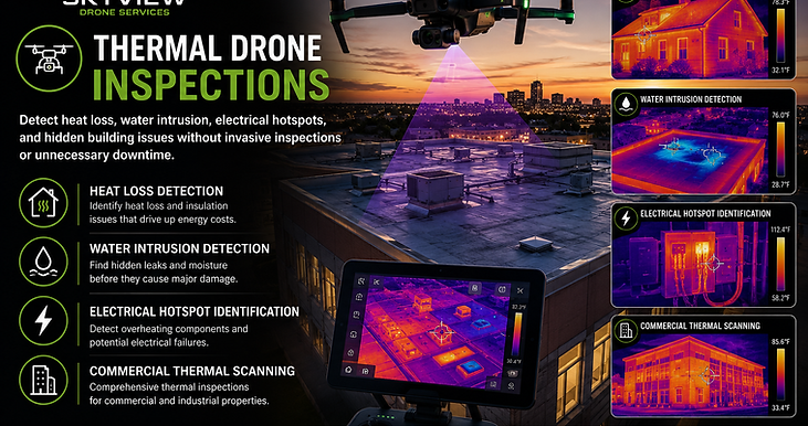
Thermal Imaging & Enterprise Mapping Specialists
MINNESOTA'S RAPID-RESPONSE DRONE SPECIALISTS
FAA-certified pilots delivering thermal inspections, mapping, emergency response, and aerial documentation throughout Minnesota.
★★★★★ Trusted by homeowners, contractors, real estate professionals, and businesses across Minnesota.
What services deliver the highest ROI?
We focus on high-impact drone services that save time, reduce costs, and eliminate risk.
Every flight is designed to produce actionable results—not just visuals.
Where Do You Provide Drone Services in Minnesota?
Serving Owatonna MN, Rochester MN, Minneapolis MN & all of Southern Minnesota with fast, professional drone services.
Same-day availability for inspections, mapping, thermal imaging, and emergency response.


Frequently Asked Questions About Drone Services in Minnesota
Trusted Across Owatonna, Rochester & Southern Minnesota | FAA Certified & Insured
?
How much do drone services cost in Minnesota?
Drone services typically range from $150 to $500+ depending on property size, service type, and urgency.
Fast, accurate quotes are provided after a quick call.
?
Do you offer same-day drone services in Minnesota?
Yes, same-day drone services are available across Owatonna MN, Rochester MN, and Southern Minnesota.
Rapid deployment ensures you get results when time matters most.
?
What types of drone services do you provide?
We provide roof inspections, thermal imaging, mapping, and aerial photography for fast, accurate results.
Get actionable data you can use immediately.
?
Why use drone inspections instead of traditional methods?
Drone inspections are faster, safer, and more accurate than manual inspections.
They reduce risk, lower costs, and deliver high-resolution data instantly.
?
Do you offer emergency drone services in Minnesota?
Yes, we provide rapid-response drone services for storm damage and urgent inspections across Southern Minnesota.
Immediate deployment is available when delays could cost you money.
?
Can drones detect roof damage or heat loss?
Yes, drones can detect roof damage, moisture issues, and heat loss using high-resolution and thermal imaging.
This allows for faster insurance claims and proactive maintenance.
?
Are you FAA certified and insured?
Yes, all drone operations are FAA certified and fully insured for safe, compliant service.
You get professional-grade results with zero risk.
?
What areas do you serve in Minnesota?
We serve Owatonna MN, Rochester MN, Minneapolis MN, and all of Southern Minnesota.
Travel is available for larger commercial projects.
?
How fast can you schedule a drone service?
Most drone services can be scheduled same-day or within 24 hours.
Fast scheduling helps you avoid delays and keep projects moving.