

Volumetric Analysis & 3D Drone Mapping Services
Accurate, Fast, and Cost-Effective Aerial Volume Calculations
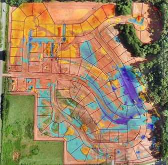
SkyView Drone Services provides expert volumetric mapping using high-resolution aerial imagery, LiDAR scanning, and AI-powered 3D modeling. Our FAA-certified pilots and advanced drone systems deliver fast, repeatable, and precise data for calculating stockpile volumes, earthwork progress, and cut/fill measurements.

WHAT IS THERMAL IMAGING?
Why Choose Drone Volumetric Mapping?
-
Millimeter-level accuracy using high-resolution LiDAR
-
Rapid data capture – map large areas in minutes
-
Safe and non-invasive alternative to traditional ground crews
-
Cost savings on time, labor, and equipment
-
3D visuals for stakeholders, permitting, or progress tracking

Industries That Benefit from Volumetric Drone Mapping
-
Construction: Cut/fill and earthwork progress tracking
-
Mining: Stockpile measurement and volumetric audits
-
Agriculture: Terrain analysis, material displacement
-
Environmental Services: Topographic changes & remediation
-
Land Development: Pre-construction volume evaluation


Benefits of Drone-Based Volumetric Mapping
Benefits of Drone-Based Volumetric Mapping
-
Traditional surveying can take days. Our drones collect high-precision volumetric data in minutes—reducing field time, labor costs, and downtime.
High-Accuracy Volume Calculations
-
Using LiDAR and photogrammetry, we deliver centimeter-level measurements for accurate stockpile tracking, cut/fill analysis, and earthwork monitoring.
Cost-Effective & Scalable Solutions
-
Eliminate costly ground surveys and manual work. Drone volumetrics offer scalable, repeatable solutions ideal for single-site or multi-location projects.
Improved Safety & Accessibility
-
Keep your team safe. Our drones access hazardous areas without boots on the ground, reducing risk and improving compliance on construction and mining sites.


Lost Pet Drone Recovery Services in Minnesota
Using thermal imaging and aerial search technology, we help reunite families with their missing pets—fast. Whether your pet is lost in fields, woods, or neighborhoods, our drone pilots are trained to locate heat signatures from the sky, offering a critical advantage when time matters most.