
Trusted by Businesses Across Minnesota
91 +
Projects
REAL JOBSITE DEPLOYMENTS
9,700 +
Miles
COVERING ACTIVE PROJECTS
Thermal Equipped
Enterprise Equipment
PROFESSIONAL SYSTEMS
Minnesota Coverage
Minnesota Coverage
STATEWIDE SERVICE
Why Companies Use Drone Data Instead of Traditional Methods
-
Faster than manual inspections
-
Safer (no climbing, no shutdowns)
-
More accurate data collection
-
Covers large areas quickly

Commercial Drone Services We Offer

-
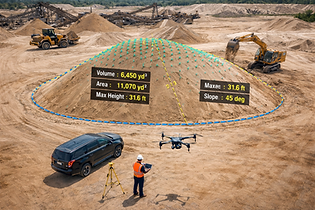
Terrain mapping
-
Elevation data
-
Site planning
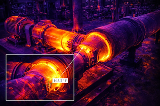
👉 Hidden problems become visible instantly


Industries We Serve


Our Process
-
Project consultation
-
Flight planning + FAA compliance
-
Data capture
-
Processing + analysis
-
Delivery

What We Can Deliver
Deliverables vary by project type, but commercial clients commonly request the following:
-
Thermal imagery and annotated inspection images
-
High-resolution aerial photos and video
-
Orthomosaic maps
-
3D models and terrain visuals
-
Volumetric calculations and stockpile reports
-
Site progress documentation
-
Visual condition documentation for assets and structures
Why Choose SkyView Drone Services MN
-
FAA-certified pilots
-
Professional-grade equipment (NOT hobby drones)
-
Fast turnaround
-
Minnesota-based rapid response


Commercial Drone Services Near You
• Owatonna
• Rochester
• Minneapolis
• Saint Paul
• Mankato
• Albert Lea
• Faribault
• Northfield
• Albert Lea
• Austin
We also travel throughout Minnesota depending on project requirements.
