top of page

Trusted by Businesses Across Minnesota
91 +
Projects
REAL FIELD DEPLOYMENTS
9,700 +
Miles
MONITORING MINNESOTA FIELDS
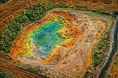
Precision Agriculture
DATA-DRIVEN FIELD ANALYSIS
Minnesota Coverage
STATEWIDE SERVICE

How Drone Technology Improves Agriculture
-
Monitor crop health across large areas
-
Detect irrigation and drainage issues
-
Identify problem areas early
-
Improve efficiency and reduce costs
-
Make data-driven decisions
Drone Services for Agriculture


Common Agricultural Use Cases
-
Crop health monitoring
-
Irrigation analysis
-
Soil and drainage evaluation
-
Field mapping and planning
-
Livestock monitoring
-
Storage and inventory measurement
Who Uses Agricultural Drone Services

-
Farmers
-
Agricultural businesses
-
Landowners
-
Agronomists
-
Farm managers


Agriculture Drone Services FAQs
1. How are drones used in agriculture? Drones are used for crop monitoring, mapping, irrigation analysis, and identifying problem areas across fields.
2. Can drones detect crop health issues? Yes, drones can identify crop stress, irrigation problems, and field inconsistencies using aerial imaging and thermal data.
3. How large of an area can drones cover? Drones can efficiently cover large agricultural areas much faster than manual inspection methods.
4. Are drone services useful for small farms? Yes, drone services benefit both small and large farms by improving efficiency and decision-making.
5. Do you provide agriculture drone services across Minnesota? Yes, SkyView Drone Services MN provides agriculture drone services statewide.
bottom of page