top of page
lidar-drone-powerline-inspection-minnesota-3d-point-cloud-analysis.webp

Energy & Utility Drone Services in Minnesota

SkyView Drone Services MN provides professional drone services for energy, utility, and infrastructure projects across Minnesota. From thermal inspections to aerial imaging and detailed site documentation, drone technology helps identify issues faster, improve safety, and reduce downtime.

Trusted by Businesses Across Minnesota

91 +

Projects

REAL INFRASTRUCTURE DEPLOYMENTS

9,700 +

Miles

INSPECTING CRITICAL SYSTEMS

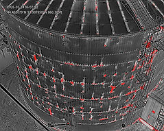
Infrastructure Inspection

POWERLINE & EQUIPMENT ANALYSIS

Minnesota Coverage

STATEWIDE SERVICE

How Drone Services Help Energy & Utility Operations

  • Inspect infrastructure safely without manual climbing

  • Detect hotspots and thermal anomalies early

  • Improve documentation for maintenance planning

  • Reduce downtime with faster aerial assessments

  • Capture detailed visuals for reporting and decision-making

Drone Services for Energy & Utility Projects

Thermal drone inspection of an industrial storage tank showing heat anomalies and hotspots detected using infrared imaging in Minnesota

Industrial Thermal Drone Inspections

Use thermal imaging to identify overheating equipment, electrical issues, and problem areas before they become costly failures.

thermal-inspection-report-analysis-industrial-equipment-minnesota.webp

Commercial Aerial Imaging & Documentation

Capture detailed aerial imagery for infrastructure assessment, project records, and ongoing utility documentation.

roof-thermal-drone-inspection-building-heat-loss-detection-minnesota-infrared-imaging.webp

Roof & Building Thermal Inspections

Inspect buildings, facilities, and support structures for heat loss, moisture issues, and visible problem areas.
Button: View Service

lidar-drone-powerline-inspection-minnesota-3d-point-cloud-analysis.webp

LiDAR Mapping, Surveying & 3D Modeling

Map utility corridors, facility grounds, and project areas with high-accuracy aerial data.
Button: View Service

Common Energy & Utility Applications

  • Utility infrastructure inspections

  • Electrical system thermal checks

  • Facility roof and building assessments

  • Substation and equipment documentation

  • Pipeline and corridor mapping

  • Maintenance planning support

Who Uses Energy & Utility Drone Services

drone-powerline-inspection-utility-infrastructure-minnesota.jpg
  • Utility companies

  • Energy facilities

  • Plant managers

  • Infrastructure contractors

  • Maintenance teams

  • Engineers and project managers

drone-technology-thermal-lidar-mapping.webp

Serving Energy & Utility Clients Across Minnesota

We provide drone services for energy, utility, and infrastructure projects across Minnesota, including Owatonna, Rochester, Minneapolis, Saint Paul, Mankato, Faribault, Northfield, Albert Lea, and surrounding areas.

skyview-drone-services-minnesota-aerial-forest-river-sunrise.webp

Energy & Utility Drone Services FAQs

1. How are drones used in energy and utility work? Drones are used for thermal inspections, infrastructure imaging, aerial documentation, and mapping of facilities and utility assets.

2. Can drones inspect utility infrastructure safely? Yes, drones help inspect hard-to-reach infrastructure while reducing the need for manual climbing and close-access risk.

3. Can thermal drones detect equipment issues? Yes, thermal drones can identify overheating components, hotspots, and temperature irregularities that may indicate problems.

4. Do you provide energy and utility drone services across Minnesota? Yes, SkyView Drone Services MN provides energy and utility drone services throughout Minnesota.

5. What types of facilities can benefit from drone inspections? Power infrastructure, utility corridors, industrial sites, substations, commercial facilities, and support buildings can all benefit from drone-based inspections.

bottom of page