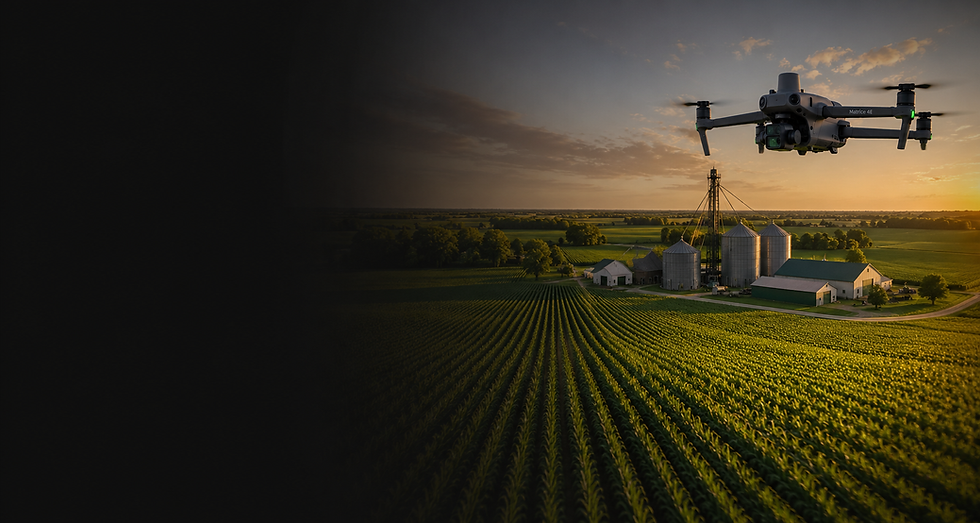
AGRICULTURE
DRONE SERVICES
IN MINNESOTA
SkyView Drone Services MN provides advanced agricultural drone services that help farmers, ranchers, agronomists, and agricultural operations improve efficiency, reduce costs, and make data-driven decisions.
From crop health monitoring to livestock inspections and aerial field mapping, our FAA-certified drone operations deliver accurate agricultural insights across Minnesota.
FAST DEPLOYMENT
INSURED
FAA-CERTIFIED
Monitor Crop Health Faster
Drone imagery helps identify stressed crops, drainage issues, pest activity, and nutrient deficiencies across large fields.
Reduce Time Spent Walking Fields
Cover hundreds of acres in a single flight and quickly identify problem areas requiring attention.
Improve Irrigation Management
Detect water distribution problems, standing water, and irrigation inefficiencies before they affect production.
Make Better Farm Decisions
Aerial data provides actionable insights for planting, spraying, harvesting, and long-term field management.
AGRICULTURE DRONE SERVICES WE PROVIDE

Crop Health Monitoring
Monitor crop conditions, plant health, growth stages, and field performance using aerial imagery and drone analysis.

Field Mapping & Surveying
Generate detailed aerial maps for farm planning, field analysis, drainage evaluation, and operational management.

Irrigation & Drainage Analysis
Identify standing water, drainage concerns, irrigation gaps, and water management opportunities.

Livestock Inspections
Monitor livestock, fencing, grazing conditions, and property assets without driving the entire operation.

Aerial Farm Documentation
Capture professional aerial imagery for crop records, insurance claims, conservation programs, and farm planning.
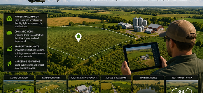
Agricultural Property Marketing
Showcase farmland, ranches, agricultural facilities, and rural properties with professional aerial photography.
WHY CHOOSE AGRICULTURAL DRONE SERVICES OVER TRADITIONAL FIELD INSPECTIONS
Agricultural drone services provide faster field coverage, better visibility, and more accurate farm intelligence without spending hours driving or walking property.
Monitor hundreds of acres in minutes
Identify crop stress before yield losses occur
Improve irrigation and drainage decisions
Reduce labor costs and scouting time
High-resolution aerial reporting for farm management

WHY SKYVIEW DRONE SERVICES MN
FAA-Certified Drone Pilots
Every agricultural operation follows FAA Part 107 standards and professional flight procedures.
Fast Minnesota Deployment
Quick scheduling for seasonal inspections, crop monitoring, and urgent agricultural assessments.
Actionable Agricultural Reporting
Receive aerial imagery and field intelligence you can use to improve farm operations.
Trusted Across Minnesota
Serving farms and agricultural operations in Owatonna MN, Rochester MN, Mankato MN, Faribault MN, and Southern Minnesota.

FREQUENTLY ASKED QUESTIONS ABOUT AGRICULTURE DRONE SERVICES
Trusted Across Owatonna MN, Rochester MN & Minnesota • FAA Certified & Insured
?
How can drone services help farmers?
Agricultural drones help farmers monitor crops, identify problem areas, improve irrigation management, and reduce scouting time.
?
Can drones detect crop stress?
Yes. Drone imagery can identify stressed areas, water issues, and field variability before problems become visible from the ground.
?
Do you provide drone services for livestock operations?
Yes. We help monitor livestock, fencing, grazing conditions, and large agricultural properties.
?
Can drone mapping improve farm planning?
Yes. Aerial maps provide valuable information for drainage analysis, field planning, conservation projects, and operational improvements.