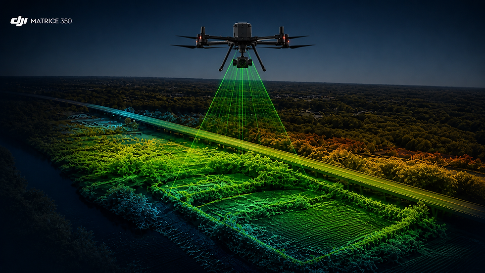
PRECISION LiDAR
DRONE MAPPING
THAT DELIVERS
RESULTS FAST
Get survey-grade LiDAR data in days, not weeks—accurate terrain models, faster decisions, and zero guesswork for your project in Minnesota.
SkyView Drone Services MN delivers rapid, high-precision mapping across Owatonna MN, Rochester MN, and Minneapolis MN.
SURVEY-GRADE
ACCURACY
FAST
TURNAROUND
TRUSTED
LOCAL EXPERTS
What is LiDAR DRONE MAPPING and why does it matter?
LiDAR mapping uses laser-based sensors to capture highly accurate terrain and structure data—even through vegetation.
SkyView Drone Services MN delivers fast, survey-grade data for construction, land development, and engineering projects across Minnesota.
What results can LiDAR mapping deliver for your project?
You get precise elevation models, terrain mapping, and actionable data fast.
We help reduce costly delays, eliminate guesswork, and accelerate project timelines in Owatonna MN, Rochester MN, and Minneapolis MN.

High-Accuracy Terrain Mapping
Capture ground elevation through trees and obstacles.
Ideal for land development, flood planning, and large-area analysis.
Construction Site Intelligence
Track progress and verify grading with exact measurements.
Reduce rework and keep projects on schedule.

Infrastructure & Engineering Support
Generate detailed 3D models for roads, utilities, and planning.
Improve decision-making with reliable, dense data sets.
Why Choose LiDAR Over Traditional Survey Methods?
Why is LiDAR better than traditional surveying or mapping?
LiDAR delivers faster, safer, and more accurate terrain data without delays or manual guesswork.
SkyView Drone Services MN helps projects move faster with precise data across Minnesota.
No Ground Delays or Heavy Field Work
Scan Large Areas Fast
Penetrates Trees & Vegetation
Reduce Project Costs & Rework
Survey-Grade Precision Data

Advanced thermal drone scan using DJI Matrice 4T identifying heat loss, HVAC inefficiencies, and hidden roof issues in real-time.
WHO NEEDS LiDAR DRONE MAPPING?
LiDAR is ideal for projects requiring precision terrain data.
If accuracy and speed matter, this service is built for you.
Land Developers
Plan smarter with detailed elevation models.
Avoid costly surprises during construction.
Engineers & Surveyors
Enhance traditional surveys with dense LiDAR data.
Improve accuracy and reduce field time.
Construction Companies
Monitor grading, volumes, and site progress.
Keep projects on budget and schedule.
OUR LIDAR MAPPING PROCESS
1
2
3
4
5
PLAN
Rapid project scoping and site review.
SCAN
High-density LiDAR drone data capture.
PROCESS
Advanced data processing and point cloud generation.
MODEL
Generate elevation models, contours, and 3D outputs.
DELIVER
Fast delivery of survey-grade LiDAR data.
We define deliverables, accuracy targets, and timeline fast.
Precision laser scanning across terrain—even through vegetation.
Clean, accurate datasets ready for real-world use.
Built for engineering, construction, and planning decisions.
Ready-to-use files with zero guesswork.
Where Do You Provide Drone Services in Minnesota?
Serving Owatonna MN, Rochester MN, Minneapolis MN, and all of Southern Minnesota with fast, professional drone services.
Same-day availability for inspections, mapping, thermal imaging, and emergency response.


FREQUENTLY ASK QUESTIONS
Trusted Across Owatonna MN, Rochester MN & Minnesota • FAA Certified & Insured
Same-Day Service • Fast Turnaround • Trusted Minnesota LiDAR Experts
DON’T LET BAD DATA DELAY YOUR PROJECT OR COST YOU THOUSANDS
Get fast, survey-grade LiDAR mapping you can trust.
Eliminate guesswork, reduce rework, and move your Minnesota project forward with confidence.